Back in 2009 the following email arrived in the barganews offices from a reader in the States.
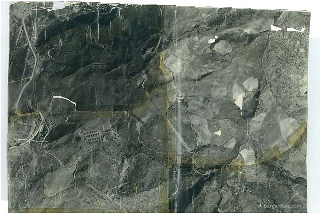
I have a WWII aerial photo of Barga (20 February 1945) that I have not been able to place on Google Earth. It was left by my father who was with the USAAF. It shows an encampment with an arrow pointing to a building, presumably to be bombed. The photo also shows some bombed out buildings, fortifications, tents, haystacks, and possible trenches. There are a few roads that run through the photo.
Is there a local historical society that I could contact to find the location? Thank you, Bob Leith.


We have done this before in the past – put up images of people or places that nobody could recognise or name and we have quite often been successful with the help of barganews readers, so maybe this time somebody out there can work out just where the above images were taken.
Is that really Barga in those photographs ?
There followed a brief flurry of other mail from Bob Leith:
The photo map had been forgotten in my closet for many years. A few months ago my 93 year old mother was cleaning out some files from her house and asked if I would like to have my father’s (John A. Leith) discharge papers from the Army Air Force…sure. I noticed that he was discharged from HQ 57th Fighter Group, part of the 12th Army Air Force.
He died in 1991 and never spoke much about the war other than he was a map maker with headquarters, specifically the XXII Tactical Air Command. Since he didn’t speak about the war I did not ask. The unwritten rule was that you never asked a veteran about his time in the war. I know they started in Africa, worked their way to Sicilia, up to Naples and then were at Alto, Corsica for awhile, and then Headquarters was later located in a tobacco factory in Florence. He did say he became friendly with a family in Florence who did work around the headquarters.
I don’t know why he kept this photo map.
I was intrigued by the discharge papers and the map; I did many Google searches, questioned my mother and pulled out the map from the closet. The map revealed a different world; bombed out buildings, trenches for defences, bomb craters and tents for soldiers. I read with great interest the work of Frank Viviano about the battle of Sommocolonia with the 92nd Infantry and Solace Wales stumbling on Lt. Fox’s grave. I have been searching Google Earth, in and around Barga for the location of the photo ever since, but have not been able to find the site.
By chance the 57th Fighter Group was having a reunion near were I live. I went and spoke to some of the surviving pilots asking them what the map was for. A squadron leader said that he would be given a “mission map”, like the one I sent to you, before each mission. They would check the regular map and then refer to the photo as they got close to the target. The squadron leader would then fly in with his P-47 Thunderbolt, drop his two 500lb bombs on the target and then the others in the group would do the same. After they dropped the bombs they would separate and strafe enemy positions, trains and trucks until they ran out of bullets and then return to base. (There is a movie called “Thunderbolt” 1945 by director William Wyler, with actual footage of bombing and strafing runs which shows what the guys in the 57th did.)
Barga was near the Gothic Line set by the Germans across Italy from Pesaro to Massa in Autumn of 1944. I think this photo was taken as part of the Spring offensive in 1945. The photo is dated 20 February but does not list the year, but I believe 1945.
We have all maybe become a bit blasè about seeing ariel photographs since the advent of Google and spy satellite images but some of the details in the images above are quite startling.
Today 11 years later, another email from Bob Leith has just arrived :
Just to add to the mix – how about some images from Barga taken during those war years. Now no longer a moon like surface with craters and bomb holes seen from above but instead at ground level its a completely different view.